


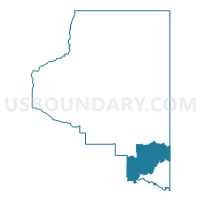
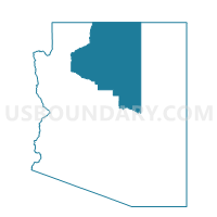
Blue Ridge Voting District, Coconino County, Arizona
About
Outline

Summary
| Unique Area Identifier | 523767 |
| Name | Blue Ridge Voting District |
| County | Coconino County |
| State | Arizona |
| Area (square miles) | 1,136.80 |
| Land Area (square miles) | 1,133.13 |
| Water Area (square miles) | 3.67 |
| % of Land Area | 99.68 |
| % of Water Area | 0.32 |
| Latitude of the Internal Point | 34.73577900 |
| Longtitude of the Internal Point | -111.15456920 |
Maps

Graphs
Select a template below for downloading or customizing gragh for Blue Ridge Voting District, Coconino County, Arizona


Neighbors
Neighoring Voting District (by Name) Neighboring Voting District on the Map
- Beaver Creek Voting District, Yavapai County, AZ
- Camp Verde 1 Voting District, Yavapai County, AZ
- Forest Lakes Voting District, Coconino County, AZ
- Heber/Overgaard Voting District, Navajo County, AZ
- Meteor Voting District, Coconino County, AZ
- Mormon Lake Voting District, Coconino County, AZ
- Pine-Strawberry Voting District, Gila County, AZ
- Verde Lakes Voting District, Yavapai County, AZ
- Whispering Pines Voting District, Gila County, AZ
- Winslow 1 Voting District, Navajo County, AZ
Top 10 Neighboring County Subdivision (by Population) Neighboring County Subdivision on the Map
- Flagstaff CCD, Coconino County, AZ (89,754)
- Camp Verde-Sedona CCD, Yavapai County, AZ (36,611)
- Payson CCD, Gila County, AZ (23,807)
- Winslow-Holbrook CCD, Navajo County, AZ (18,068)
Top 10 Neighboring Place (by Population) Neighboring Place on the Map
Top 10 Neighboring Elementary School District (by Population) Neighboring Elementary School District on the Map
- Beaver Creek Elementary District, AZ (4,808)
- Pine Strawberry Elementary District, AZ (2,952)
- Chevelon Butte School District, AZ (650)
Top 10 Neighboring Unified School District (by Population) Neighboring Unified School District on the Map
- Flagstaff Unified District, AZ (91,658)
- Payson Unified District, AZ (21,636)
- Winslow Unified District, AZ (11,556)
- Camp Verde Unified District, AZ (11,452)
Top 10 Neighboring State Legislative District Lower Chamber (by Population) Neighboring State Legislative District Lower Chamber on the Map
Top 10 Neighboring State Legislative District Upper Chamber (by Population) Neighboring State Legislative District Upper Chamber on the Map
Top 10 Neighboring 111th Congressional District (by Population) Neighboring 111th Congressional District on the Map
Top 10 Neighboring Census Tract (by Population) Neighboring Census Tract on the Map
- Census Tract 9605, Navajo County, AZ (4,144)
- Census Tract 16.02, Yavapai County, AZ (3,918)
- Census Tract 15, Coconino County, AZ (3,186)
- Census Tract 1, Gila County, AZ (2,949)
- Census Tract 2, Gila County, AZ (2,227)
Top 10 Neighboring 5-Digit ZIP Code Tabulation Area (by Population) Neighboring 5-Digit ZIP Code Tabulation Area on the Map
- 86001, AZ (40,776)
- 85541, AZ (21,877)
- 86047, AZ (14,970)
- 86322, AZ (11,480)
- 86335, AZ (4,806)
- 85544, AZ (2,949)
- 86024, AZ (703)
- 86017, AZ (667)
- 86038, AZ (77)